The success of the Erie Cavnal which opened 200 years ago in 1825 caused folks around New York to petition the State to build a canal to their town. At that time roads were typically very rough – early turnpikes were mainly oriented east-west across New York, few went north or south.
Eventually, 16 lateral canals were built off the Erie Canal by the state totaling more than 750 miles and extending to various parts of New York.
Settlers in the Chenango River Valley petitioned the State and engaged in a major lobbying campaign, led by Oneida County‘s Col. Reuben Tower of Waterville, for a canal to transport farm produce from the Valley and gain easier access to manufactured goods.
The Chenango Valley was not heavily populated in the 1820s – about 20,000 people lived in Chenango County and only about 8,000 in Broome County. Settlers moving west mainly by-passed the Chenango Valley and by the 1830s many New Englanders had reached Ohio by other routes.
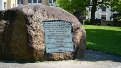
The Chenango Canal was authorized by an act of the legislature on February 23, 1833. The work of construction was begun the same year and was finished in 1837. It facilitated transportation between Utica and Binghamton and connected the Susquehanna River to the Erie Canal.
Irish immigrants did much of the hard manual labor with shovels and pick axes. It was not without its labor struggles, notably around Deansville (Deansboro), where a strike was s uppressed by the state militia.
From it’s starting point in West Utica the Canal proceeds through Clinton and flowed over today’s R routes 5, 8, 12. Chenango Avenue in Clinton was the bed of the old canal and later filled to become a village street.
From Utica to the summit at Bouckville in Madison County the greatest elevation on its line was 1,142 feet above sea level. It took a series of seventy-six locks, a rise of 706 feet to go from Utica to Bouckville. From there the canal descended 303 feet through thirty-eight locks to the southern terminus at the junction of the Susquehanna and Chenango Rivers in Binghamton.
Much of the water supply was obtained from the elevated water bodies of southern Madison County and from Madison Brook, Woodman’s Pond, Leland’s Pond, Bradley’s Brook, Hatch’s Lake and Eaton Brook Reservoir. These are called the southern feeder system.
The length of the canal between Utica and Binghamton was 97 miles, and of its feeders, thirteen and three-fourths miles. Freight consisted of coal, iron ore, cast iron, hops, cider, and lumber. Passengers were few and mainly between Norwich and Binghamton.
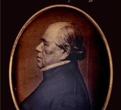
The project’s chief engineer was John B. Jervis (1795-1885), who had started as an axe man on the Erie Canal, and is believed to have been the first to employ impounded waters (reservoirs) to supply water to a canal. Many of surveyors and engineers had been trained at Rensselaer Polytechnic Institute (RPI) in Troy, NY, founded in 1824.
 Impounded reservoirs and other waters were diverted to flow north into the Oriskany Creek. A drive today between Solsville and Oriskany Falls passes many locks and the abandoned canal bed filled with cat tails. A close look at the remains of the canal can also be seen between Deansboro and Oriskany Falls off route 12-B.
The cost of building the Chenango Canal was $2,500,000 (about twice the original estimate) and although the dreams of advocates for the canal in the 1830s seem to have been fulfilled initially, in its 40 years of operation (1834 to 1878) the Chenango never brought in enough tolls to pay even the cost of annual repairs.
It also failed to populate the valley and did not stimulate the economy of the valley as much as expected. The costs of maintenance, numerous repairs, plus declining tolls and competition from the railroads, which arrived in Utica from Albany in 1835-6, added nails to the coffin.
Illustrations. from above: a postcard showing the abandoned Chenango Canal near Utica in ca. 1900; an 1855 map showing the Chenango Canal intersecting the Erie Canal in Utica including four sets of locks; and a detail from “New York State Canal System Map,” in Sherman Williams, New York’s Part in History, 1915.
Source link