Science

Meet the storm chasers on the hunt for extreme hail

This is a supercell photographed near Arnett, Oklahoma on June 17th. At the moment of the picture, a tornado is ongoing in the center of the image buried in rain, and hail bigger than 55mm (2.17???) is falling and being collected by the hail hunting vehicle. The lightning was prolific because the storm was well over 65,000 feet tall during its peak strength. The lightning was so constant that in 1/8th of a second (the exposure time of this picture), I was able to capture 3 strikes. Most of the lightning was positive, which is stronger than the typical lightning strike which are negative. This can be an indicator of an abundance of hail within the storm, as hail can increase the amount of built up electrical charge within the updraft. Positive strikes typically originate from the top of the storm (anvil) and are characterized by one singular channel without much branching (leftmost strike). Typically striking within the inflow of the storm, they also only strike once instead of strobing with multiple strokes/pulses like negatively charged lightning does. Hope this is enough information about the storm! I can always share more if needed.

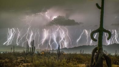
A tornado captured near Arnett, Oklahoma

Ethan Mok

Most storm chasers live for tornadoes. A few live for hailstorms. That is certainly true of the more than 50 weather scientists involved in the largest-ever field survey focused on extreme hail, now under way across the US Great Plains.

Since mid-May, the researchers involved in the ICECHIP project have raced from the Texas panhandle to South Dakota in search of storms that produce the biggest hail – from golf balls (pictured below) to grapefruits of ice. Hail causes billions of dollars of damage each year, but forecasts of which storms will produce the most hazardous kinds are unreliable. ICECHIP wants to change that by measuring everything possible about these storms and relating it to the ice they generate.

New Scientist. Science news and long reads from expert journalists, covering developments in science, technology, health and the environment on the website and the magazine.

An average day of the campaign involves intensive forecasting to track down a storm like the one in the main picture, captured near Arnett, Oklahoma, on 17 June by Ethan Mok, a member of the ICECHIP team. A tornado, here obscured by rain, has just touched down in the hail core of the storm, where most of the hail is falling.

New Scientist. Science news and long reads from expert journalists, covering developments in science, technology, health and the environment on the website and the magazine.

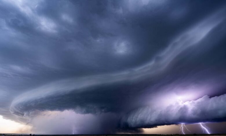
Vehicles surround the storm to measure it

Will Sardinsky

As a fortified truck called the Hail Hunter drives into the core to collect the biggest, freshest stones, dozens of other vehicles (pictured above) surround the storm to measure it using mobile radar, weather balloons and a fixed-wing drone.

New Scientist. Science news and long reads from expert journalists, covering developments in science, technology, health and the environment on the website and the magazine.

Hail-impact disdrometer

Will Sardinsky

Other teams place specialised equipment such as a hail-impact disdrometer (shown above) in the path of the storm to record the size distribution of the hail and its impact velocity.

New Scientist. Science news and long reads from expert journalists, covering developments in science, technology, health and the environment on the website and the magazine.

Once the storm has passed, the researchers return to survey the damage across the swathe of hail and collect as much ice as they can before the precious data melts (pictured above).

Topics:


Source link

Related Articles

Leave a Reply

Your email address will not be published. Required fields are marked *