 During the American Revolution Half-Way Brook in what is now Queensbury, NY appears in the lime-light of history only a few times, although the buildings still standing from the French and Indian War (1754-1763) were doubtless used by the troops passing between Lake George and Fort Edward, until the time of the John Burgoyne’s campaign toward Saratoga.
There was also a ford at Half-Way Brook for watering horses and cattle, which was in use up to the present century.
According to historian William L. Stone (1792/93-1844), General Burgoyne detached Baron Friedrich Adolf Riedesel with three battalions to “John’s Farm between Forts George and Edward,” in order to keep open the roadway between the two places, and also to look after and progress the provisions, stores and supplies from Lake George to Fort Edward, preparatory to Burgoyne’s advance south.
In Baron Riedesel’s memoirs he states that “in that place he was completely cut off from the army, so he entrenched himself in a strongly fortified camp so that he might be able to defend himself to the last man.”
The place of his encampment has been quite definitely fixed by Dr. Austin W. Holden, the author of A History of the Town of Queensbury (1874), William Stone and the late Judge William Hay, one of the best of authorities on local matters, as having been on the site of the old Half-Way block house, on the north of the brook and the fortified camp at the “Garrison Grounds” on the opposite or south side of the stream.
Here they remained until the September 11, 1777, when the camp was broken up and the march southward begun.
After the Second Battle of Saratoga on October 7, Burgoyne’s army retreated north hoping to cross the Hudson River and fall back to Fort Edward.
On the night of October 11–12, General John Stark and about 1,000 militiamen crossed the Hudson River and seized the high ground north of the British camp (a site now known as Stark’s Knob). This sealed off the last viable river crossing and road back to Fort Edward.
 A fortified camp commanding the Lake George military road was constructed by the Americans, further cutting off the possibility of a retreat by Burgoyne. William L. Stone, in his “Burgoyne’s Campaign,” says: “This was located on the site of Fort Amherst.”
The Marquis de Chastelleux in his travels also speaks of this camp as follows:
“On leaving the valley and pursuing the road to Lake George is a tolerable military position which was occupied in the war before last. It is a sort of an entrenched camp, adapted to abatis, guarding the passage from the woods and commanding the valleys.”
Assuming that this was the spot in question, the “Half-Way Brook” post was a factor in bringing on the surrender at Saratoga.
Burgoyne’s Council of War, held October 13, 1777, was informed “that the enemy was entrenched at the fords of Fort Edward and likewise occupied the strong position on the Pine Plains between Fort George and Fort Edward,” and decided a retreat was impossible and an honorable capitulation should be considered.
According to Article IX of the Saratoga “Convention,” “All Canadians and persons connected with the Canadian Establishment,” “Independent Companies ” (which included the Loyalists) and miscellaneous followers of the army were to be conducted by the shortest route to the first British post on Lake George, under the same conditions of surrender as the regular troops.
Pursuant to this agreement, soon after the capitulation on the morning of October 17th, the defeated British, under escort of a guard of American soldiers, were marched to Half-Way Brook on their way to Canada, and from there allowed to pursue their journey to their homes unmolested.
 During 1780, the old military road was infested with roving bands of Loyalists and their Indigenous allies. The last massacre at Half-Way Brook of which history has record occurred in June or July of this year, when a man by the name of Koon, from Kingsbury, and three laborers, on their way to Fort George, were found dead and scalped on the highway near Half-Way Brook.
In the fall of 1780, Major Christopher Carleton of the 29th Regiment, with about twelve hundred men, regulars, Loyalists and Native allies, raided through Kingsbury and Queensbury, capturing Fort Ann on the 10th of October, and Fort George on the following day.
At this time, all the buildings and structures in Kingsbury and Queensbury in the path of the raid were destroyed by fire by the enemy, causing 1780 to go down in local annals as “the year of the great burning.”
In order to speedily reach Fort George, Major Carleton led his forces from Kingsbury Street directly across country, through the then existing road entering the Lake George highway near the Half-Way Brook post.
Holden’s History of Queensbury states that Ichaibod Merritt, son-in-law of Abraham Wing, a founder, and father of Joseph, said to be the first white child born in Queensbury, erected the first frame house in Queensbury, on one of the sections of the Town Plot, near the Half-Way Brook, which was burned at this time.
Battle of Fort Anne
Connected in a way with the history of the Half-Way Brook, is the battle which took place at Fort Ann July 8, 1777, between the Americans under Colonel Pierse Long (1739-1789) and Colonel Henry K. Van Rensselaer (1744-1816) and the 9th British Regiment of Burgoyne’s army under Lieutenant Colonel John Hill.
The scene of this affair is located only three-quarters of a mile from the point where the Half-Way Brook enters Wood Creek at Fort Ann village, and the semi-successful fight put up by Long’s forces, was one of the first serious interferences which Burgoyne received in his plan of campaign.
In 1858 William Welles erected a marble monument on the south end of Battle Hill to commemorate this battle. This was destroyed by an act of vandalism about 1870.
After this period the name of the Half-Way Brook practically disappears from the domain of national history.
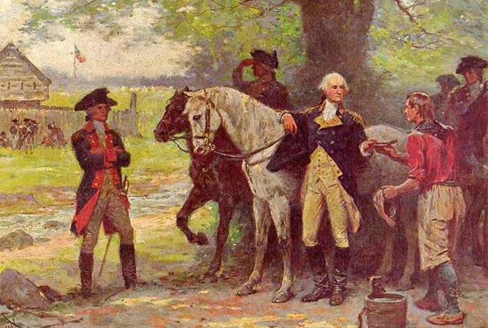
 In August, 1783, while on a journey of inspection of the northern battlefields and fortifications at Saratoga, Fort Edward, Lake George, Ticonderoga and Crown Point, General George Washington, accompanied by Governor George Clinton, General Alexander Hamilton, Colonels David Humphreys and Nicholas Fish, halted for rest and refreshment at the “Butler Brook,” one of the branches of Half-Way Brook.
Near the entrance to what is now Crandall Park they were waited on by one Briggs at work in a neighboring field, who brought a cup and pail and supplied water from the brook to satisfy their thirst.
Two other future Presidents of our country, Thomas Jefferson and James Madison, likewise passed through the town in 1791 to visit the many scenes of historic interest at the north.
Read More About Half-Way Brook
This essay was drawn from James Austin Holden’s “The Half-Way Brook in History” published in the Proceedings of the New York State Historical Association, Volume 6 (1906). It was edited for clarity and annotated by John Warren.
Illustrations, from above: “The Country between Crown Point and Albany being the Great Pass from the English to the French Settlements in North America,” ca. 1758, with Halfway brook is shown as The Forked Creek; Fort Amherst, Halfway Brook Post and the Garrison Grounds in what is now Queensbury, NY; Fort George – Carleton’s Raid of 1780 historical marker provided by Lake George Battlefield Park Alliance; and “At Halfway Brook in Queensbury” — George Washington depicted during his 1783 trip to northern New York (commissioned by the Glens Falls Insurance).
Source link